
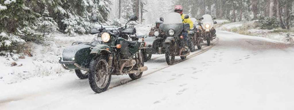
A group of Ural owners celebrated the first glimpse of snow in Colorado with a mountain pass tour. They rode from Longmont, CO to Steamboat Springs, CO via Cameron Pass (10,249 feet) and Buffalo Pass (10,295 feet, this was the snowy dirt road). They returned via Rabbit Ears Pass (9,426 feet, snowy paved road) and Berthoud Pass (11,306 feet).
Longmont, Colorado
The City of Longmont is a Home Rule Municipality in Boulder and Weld counties of the U.S. state of Colorado. Longmont is located northeast of the county seat of Boulder and 33 miles (53 km) north-northwest of the Colorado State Capitol in Denver.
The word “Longmont” comes from Longs Peak, a prominent mountain named for explorer Stephen H. Long that is clearly visible from Longmont, and “mont”, from the French word “montagne” for mountain.
Steamboat Springs, Colorado
The City of Steamboat Springs, often shortened to just Steamboat, is a Home Rule Municipality that is the county seat and the most populous city of Routt County, Colorado, United States.
The city is an internationally known winter ski resort destination. The Steamboat Springs tourism industry is highlighted by Steamboat Ski Resort, which is on Mount Werner in the Park Range just east of the town. It also contains the much smaller Howelsen Ski Area.
It is located in the upper valley of the Yampa River, along U.S. Highway 40 just west of the Continental Divide and Rabbit Ears Pass.
Cameron Pass, Colorado
Cameron Pass is a 10,276 ft (3,132 m) elevation mountain pass in the Rocky Mountains in north central Colorado in the United States. The pass is a gap between the south end of the Medicine Bow Mountains and the north end of the Never Summer Mountains. It sits on the border between Jackson County and Larimer County, approximately 3 mi (5 km) north of the boundary of Rocky Mountain National Park. The pass provides the most convenient route between Fort Collins and Walden in North Park, using State Highway 14.
The pass was named for Robert Cameron, the founder of the Fort Collins Agricultural Colony in the 1870s. The pass was surveyed several times for railroads, including once by the Union Pacific Railroad as a possible route for a line through the Rockies. No railroad was ever built over the pass however. The pass is located the boundary of the Roosevelt National Forest and the Colorado State Forest State Park. Parking lots on the east and west sides of the pass, as well as at the summit allow access to nearby trails that are popular both for hiking in the summer and cross-country skiing in the winter. The pass receives much snow during the winter months and is prone to avalanches, but it usually remains open all-year round. The pass has a mild approach from the East, and is steep from the West.
The pass is drained on the north side by a tributary of the Cache la Poudre River in the basin of the South Platte River. It is drained on the south side by the Michigan River, a tributary of the North Platte River in North Park.
Buffalo Pass, Colorado
Buffalo Pass, elevation 10,295 ft (3,138 m), is a mountain pass that crosses the Continental Divide in the Park Range of the Rocky Mountains of northern Colorado in the United States.
Rabbit Ears Pass, Colorado
Rabbit Ears Pass (el. 9426 ft, 2873 m) is a high mountain pass in the Rocky Mountains of northern Colorado in the United States. The summit has the shape of rabbit ears, which displays two large columns of basalt rock formations from the second volcanic episode. Rabbit Ears Peak is underlain by a pink tuff and the basalt immediately to the west is underlain by red, vesicular ash. Volcanic breccia occurs only at the Peak, which is a large stratified breccia pile. The three basal layers are cut by a basalt dike immediately beneath the peak. From petrographic evidence there appears to have been one period of lava flows and this surface can be seen at Rabbit Ears Peak.
Berthoud Pass, Colorado
Berthoud Pass is a high mountain pass in the Rocky Mountains of central Colorado in the United States.
The pass is located west of Denver, and provides a high route between upper Clear Creek Canyon to the upper valley of the Fraser River in Middle Park to the north. The pass traverses the continental divide at the Front Range, on the border between Clear Creek County and Grand County.
Harry Yount at Berthoud Pass in 1874
The pass is named for Edward L. Berthoud, the chief surveyor of the Colorado Central Railroad during the 1870s. Accompanied by Jim Bridger, Berthoud discovered the pass in July 1861 while surveying a possible route for the railroad. Berthoud concluded that the pass was suitable as a wagon road, but not as a railroad, and was then hired by the Central Overland California and Pikes Peak Express Company to survey a route over the pass to Salt Lake.
(From Wikipedia, the free encyclopedia)


A group of Ural owners celebrated the first glimpse of snow in Colorado with a mountain pass tour. They rode from Longmont, CO to Steamboat Springs, CO via Cameron Pass (10,249 feet) and Buffalo Pass (10,295 feet, this was the snowy dirt road). They returned via Rabbit Ears Pass (9,426 feet, snowy paved road) and Berthoud Pass (11,306 feet).
(From Left to Right) Deana, Jay, Janet, Roy, Cookie, John, Dan, Anna, and Francisco all ready for the day’s ride. Picture by Tim, who’s green bike is on the farthest left.

Photos: Tim Laughlin, Jay B and Deana H, john s and cookie

Michael Le Pard (“Mr. Totalmotorcycle”) is the Founder of Total Motorcycle, the world’s largest motorcycle information site, trusted by over 430 million riders since 1999. With over 34 years of experience in motorcycles, gear and rider culture, he has built a global community dedicated to empowering and inspiring motorcyclists.
Total Motorcycle remains his passion project. Combining expert research, hands‑on knowledge and a commitment to helping riders make informed decisions about bikes, gear and safety worldwide.
